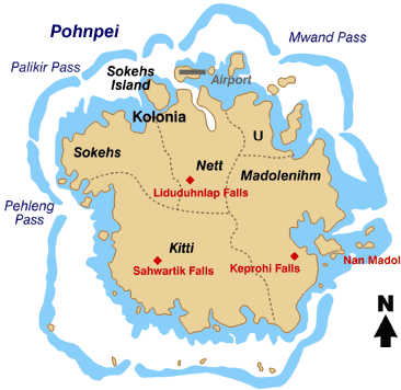
Vaizdas:Pohnpei map.gif
Pohnpei_map.gif (366 × 356 taškų, rinkmenos dydis: 19 KiB, MIME tipas: image/gif)
Rinkmenos istorija
Paspauskite ant datos/laiko, kad pamatytumėte rinkmeną tokią, kokia ji buvo tuo metu.
| Data/Laikas | Miniatiūra | Matmenys | Naudotojas | Paaiškinimas | |
|---|---|---|---|---|---|
| dabartinis | 22:59, 7 balandžio 2008 |  | 366 × 356 (19 KiB) | Scanlan | {{Information |Description=Map of the Island of Pohnpei, in the Federated States of Micronesia |Source=http://www.doi.gov/oia/press/2008/04042008.html |Date=April 4, 2008 |Author= United States government Department of the Interior |Permission= |other |
Paveikslėlio naudojimas
Paveikslėlis yra naudojamas šiuose puslapiuose:
Visuotinis rinkmenos naudojimas
Ši rinkmena naudojama šiose viki svetainėse:
- Naudojama ar.wikipedia.org
- Naudojama bo.wikipedia.org
- Naudojama ca.wikipedia.org
- Naudojama cs.wikipedia.org
- Naudojama de.wikipedia.org
- Naudojama en.wikipedia.org
- Naudojama eo.wikipedia.org
- Naudojama es.wikipedia.org
- Naudojama fa.wikipedia.org
- Naudojama fr.wikipedia.org
- Naudojama gl.wikipedia.org
- Naudojama it.wikipedia.org
- Naudojama ja.wikipedia.org
- Naudojama ka.wikipedia.org
- Naudojama ko.wikipedia.org
Žiūrėti visuotinį šios rinkmenos naudojimą.


