
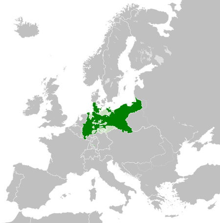
Vaizdas:Kingdom of Prussia 1870.svg

Rinkmenos SVG peržiūros PNG dydisː 450 × 456 taškų. Kitos 5 rezoliucijos: 237 × 240 taškų | 474 × 480 taškų | 758 × 768 taškų | 1 011 × 1 024 taškų | 2 021 × 2 048 taškų.
Didesnės raiškos iliustracija (SVG rinkmena, formaliai 450 × 456 taškų, rinkmenos dydis: 705 KiB)
| Ši byla yra iš bendros Wikimedia Commons nemokamų resursų duomenų bazės, palaikomos Wikimedia Foundation organizacijos. Norėdami sužinoti licencijavimo smulkmenas, žiūrėkite paveikslėlio aprašymą |  |
Į paveikslėlio aprašymą |
Aprašymas
Šis vektorinis paveikslėlis sukurtas su Inkscape .


.svg)
.svg)
.svg)
.svg)
.svg)


.svg)
.svg)
.svg)


.png)
.png)


.svg)


.svg)

.svg)


.svg)
.svg)
.svg)
.svg)


.svg)
.png)


.svg)


.svg)
.svg)


.svg)


.svg)


.svg)
.svg)
.svg)
.svg)
.svg)
.svg)
.svg)
_cropped.svg)
.svg)
.svg)
.svg)
.svg)
.svg)
.svg)
.svg)
.svg)
.svg)
.svg)
.svg)
.svg)
.svg)
.svg)
.svg)
.svg)
.svg)
.svg)
.svg)
.svg)
.svg)
.svg)
.svg)
.svg)
.svg)
.svg)
.svg)
.svg)
.svg)
.svg)
.svg)
.svg)
.svg)
.svg)
.svg)
.svg)
.svg)
.svg)
.svg)
.svg)
.svg)
.svg)
.svg)
.svg)
.svg)
Licencija
This file is licensed under the Creative Commons Attribution-Share Alike 4.0 International license.
- Jūs galite:
- dalintis – kopijuoti, platinti bei persiųsti šį darbą
- pri(si)taikyti – adaptuoti darbą
- Su šiomis sąlygomis:
- autoriaus nurodymas – Turite pateikti atitinkamą kreditą, pateikti nuorodą į licenciją ir nurodyti, ar buvo atlikti pakeitimai. Tai galite padaryti bet kokiu būdu, bet ne taip, kad licencijos išdavėjas patvirtintų jus ar jūsų naudojimą.
- dalinkis panašiai – Jei perdirbsite, redaguosite ar atkursite šį darbą, jį galėsite platinti tik su tokia pačia ar panašia į šią licencija.
Rinkmenos istorija
Paspauskite ant datos/laiko, kad pamatytumėte rinkmeną tokią, kokia ji buvo tuo metu.
| Data/Laikas | Miniatiūra | Matmenys | Naudotojas | Paaiškinimas | |
|---|---|---|---|---|---|
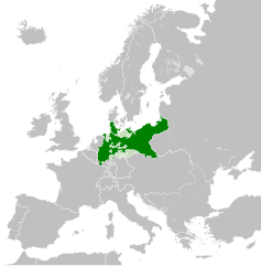
| dabartinis | 05:54, 1 birželio 2016 | | 450 × 456 (705 KiB) | Alphathon | Various corrections to the states of the North German Confederation |
| 08:22, 31 gegužės 2016 |  | 450 × 456 (662 KiB) | Alphathon | Minor corrections (Tarasp and post-1818 German Confederation border change) | |
| 05:40, 31 gegužės 2016 |  | 450 × 456 (662 KiB) | Alphathon | == {{int:filedesc}} == {{Inkscape}} {{Information |Description={{en|A map of the en:Kingdom of Prussia within the North German Confederation and within Europe circa 1870 CE.}} |Source= {{Derived from|Blank_map_of_Europe.svg|display=50}} |Da... |
Paveikslėlio naudojimas
Paveikslėlis yra naudojamas šiuose puslapiuose:
Visuotinis rinkmenos naudojimas
Ši rinkmena naudojama šiose viki svetainėse:
- Naudojama af.wiktionary.org
- Naudojama ar.wikipedia.org
- Naudojama bn.wikipedia.org
- Naudojama ckb.wikipedia.org
- Naudojama en.wikipedia.org
- Naudojama eo.wiktionary.org
- Naudojama es.wikipedia.org
- Naudojama es.wiktionary.org
- Naudojama eu.wikipedia.org
- Naudojama fa.wikipedia.org
- Naudojama fi.wikipedia.org
- Naudojama he.wikipedia.org
- Naudojama hu.wikipedia.org
- Naudojama is.wikipedia.org
- Naudojama it.wikipedia.org
- Naudojama li.wiktionary.org
- Naudojama lld.wikipedia.org
- Naudojama mn.wikipedia.org
- Naudojama pl.wikipedia.org
- Naudojama rue.wikipedia.org
- Naudojama ru.wikipedia.org
- Naudojama ru.wiktionary.org
- Naudojama sk.wikipedia.org
- Naudojama szl.wikipedia.org
- Naudojama tr.wikipedia.org
- Naudojama uk.wikipedia.org
- Naudojama uz.wikipedia.org
- Naudojama xmf.wikipedia.org
- Naudojama zh.wikipedia.org